Editor’s note: This is the second in a series on the local housing crunch, who it affects and what’s causing the squeeze. The first part that outlines the squeeze on the market ran Friday, May 3, and third part is coming Monday, May 13.
By Randi B. Hagi, senior contributor
The way Harrisonburg zones for new housing could change drastically over the next several years as city leaders wrestle with their approach to new developments. And early signs of those changes are starting this month.
The Planning Commission, in fact, will hold a public hearing about a new zoning class — one that would lessen the required lot size a developer needs to build a home.
In the meantime, though, the zoning rules are — along with statewide stormwater management regulations — contributing to a bottleneck of new home construction.
First, the city’s footprint is fairly well filled already. About 400 acres of land could be developed for housing out of Harrisonburg’s more than 11,000 acres, said J.M. Snell, co-owner of Valley Renovators, Inc., a general contractor company that builds custom homes, townhouses and light commercial buildings throughout the Shenandoah Valley.
And for new construction to move forward on those open acres, barriers remain:
- Regulations, such as those around stormwater management, cost the developer in either fees or the time and expense of property remediation.
- The costs of building materials are increasing. Snell said wood, masonry, and certain metals and plastics are all getting more expensive.
- There is also a limited number of contractors and subcontractors in the area relative to how many new construction projects are available, such as JMU’s multifaceted expansion and the planned new high school.
- And landowners have to be willing to sell at a “reasonable” price to start the whole chain.
“When you have each of those people reasonably trying to balance risk and reward and profit, it’s hard for everyone to have a piece of the pie,” said Scott Rogers, a realtor with Funkhouser Real Estate Group who has been studying the area’s housing market trends for 12 years.
But for the pie to even be on the table, so to speak, the land in question has to be zoned appropriately, or have a special use permit approved by the planning commission and city council.
City zoning ordinance limits what kinds of housing can be built, and for how many people in a given area, as well as the number of units overall that can be built per acre.
Demystifying the zoning puzzle
Residential zones are classified on a scale from R1 to R7, where only certain types of houses can be built in those zones.
R1 is the least dense, for single-family detached homes.
R5 is described as “high density” – townhouses and apartments.
R6 and R7 are low and medium densities, respectively, of “residential planned communities” that include a mix of housing types.
Much of the residential districts nearing Court Square are zoned R2 or R3, which are slightly more dense than the single-family homes zoning. Other R3 districts stretch across a large swath by JMU’s campus and around the east end of Reservoir Street.
A few small plots of higher density zones are scattered off of Old Furnace Road, Stone Spring Road, and South Main Street. Moving east and west of city center takes you to large tracts of low density R1, like most of the Old Town and Sunset Heights neighborhoods.
Those “medium density” neighborhoods close to downtown – think Northeast neighborhood, Collicello street, et cetera – require a 7,000 square foot plot size for each single-family dwelling. That means one can legally build five to six such dwellings per acre. If you’re building duplexes, lot sizes permit eight total units – so, four duplexes.
Ritchie Vaughan, a realtor with Kline May Realty, said that “doesn’t seem medium” density to her, particularly given the high demand to live close to the jobs, culture, and transportation options downtown.
Vaughan added that, in her work as a realtor, she sees a lot of parcels that are legally too small for a house to be built.
“There’s a lot of non-conforming lots already,” she said. “So prior to the 1950s or 1960s, we didn’t have the zoning ordinances that we have right now. So people back then were able to split their lots and make smaller lots that had modest-sized homes, and they were affordable, and we can’t do that anymore.”
Changes afoot?
Thanh Dang, the city’s assistant director of planning and community development, said an appropriate level of density is one of many factors to be considered in her department’s upcoming overhaul of the entire zoning ordinance.
“The last time our zoning ordinance was updated was in 1996 … when it was last comprehensively updated. We’ve done many amendments since that time, but this time we are really due to look at it comprehensively,” Dang said.
The entire process will take about three years and include public workshops to gather community input.
In the meantime, however, Dang’s office is working on adding a new zoning class called R8 for “small lot residential,” which would allow for construction of homes that would have smaller yards. And that could increase the housing density in the city.
A staff report including the R8 proposal and staff’s recommendations was published on the city website on Friday.
The proposal, first pitched to the city by local engineer Dick Blackwell, is aimed at providing ” an affordable dwelling to a greater range” of homebuyers, including first-time homebuyers, according to the proposal.
There will be a public hearing regarding the proposal at the May 8 Planning Commission meeting.
Adding R8 to the books would “give people the opportunity to rezone their properties to a designation that allows for smaller lot sizes for single-family detached as well as duplex homes,” Dang said.
For instance, single-family detached homes could be built on lots as small as 2,800 square feet, which is equivalent to a zoning density of 15 dwelling units per acre, according to the proposal. And a duplex could be built on a lot as small as 1,800 square feet.
In addition, someone who owns a home on a relatively large lot could divide it and build a second structure to sell or rent out.
Consequences of density
However, one of the primary functions of zoning regulations is to keep a neighborhood population at a level that can be sustained by that neighborhood’s infrastructure. Water and sewer lines, road widths, sidewalks, traffic lights and patterns all are built to accommodate a certain number of people.
Land can’t just be rezoned for a higher density without taking that into consideration – which further inhibits new housing from being built.
Builder J.M. Snell is familiar with this challenge.
“That rezoning process starts with a reconsideration that, if all along we planned your land as (farm or agriculture), we probably don’t have enough sewer or water headed in that direction, and maybe the roads aren’t big enough,” Snell said.

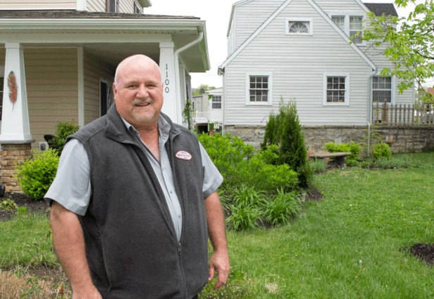
J.M. Snell at the Chicago Park development his company, Valley Renovators, is building. Of the 15 units planned, five have been purchased. Four others “don’t even have a foundation” yet.
If a new construction project brings in a flood of new residents beyond the infrastructure’s capacity, there is an avenue for developers to still get that land rezoned.
A developer can offer to pay for certain infrastructure updates so that the land can be accommodate more people living there, thus making it possible to rezone. That’s a called a “proactive offer,” or proffer, for short.
Snell calls that “a sustainable burden on the new subdivision’s buyers for them to bear for the infrastructure impact on the community.”
As part of the Home Builders Association of Virginia, Snell has worked with the state legislature to appropriately regulate proffers, so that localities cannot require them in an extortionary manner, but still keep them a viable option for developers that can shoulder those costs.
Dang said developers also use proffers to gain community support for a new project, especially if residents accustomed to a low-density neighborhood aren’t keen on tall, multiple-family complexes moving in.
A developer could then say, “‘there’s a single-family neighborhood over there, and they have concerns about having to look in their backyard at a parking lot … I’m going to put in some dense landscaping here to protect your view,’” Dang said.
Fear of the rezone?
These negotiations take place in the city’s planning commission, are reviewed by city staff, and then ultimately approved or denied by city council. And even though the zoning ordinance is outdated, Dang said there is a benefit to going through that individualized rezoning process.
“I think it’s a valuable process because it gives … staff, planning commission, city council, and the community the opportunity to understand what is being planned there, maybe to talk to them and share … concerns,” Dang said. “Whereas if the city proactively rezoned all properties … we don’t get to have that opportunity for that dialogue.”
Rezoning applications are more likely to be approved if they jibe with the 2018 Comprehensive Plan, which gives a long-term vision for the city’s development.
The plan’s guide for land use suggests more “mixed use” and “neighborhood residential” sectors downtown – both of which would allow a variety of housing types within the same neighborhoods.
The map also includes more high density residential sectors in the Southeast quadrant of the city, although those areas are small.
Dang acknowledged that whatever changes happen with the zoning ordinance, whether piecemeal or wholesale, might invite “resistance or fear of the unknown.”
To that end, she sees her role as both an educator and a facilitator, “in hopes of finding consensus between sometimes conflicting ideas, opinions and stakeholders.”
For example, if a developer wanted to rezone property — say, for a small retail development — in a mostly residential neighborhood, nearby residents sometimes come to Dang’s office to express their concerns.
Dang said she will go over the comprehensive plan with concerned residents and explain any technical terminology they may not be familiar with, so that they can “better articulate what their concerns are, or solutions they might propose.”
Her staff also encourages developers to talk to neighbors about potential concerns before they ever submit a rezoning application. As with any negotiation, “sometimes there is no consensus,” Dang said, but she said she hopes that her office at least helps both sides communicate with each other.

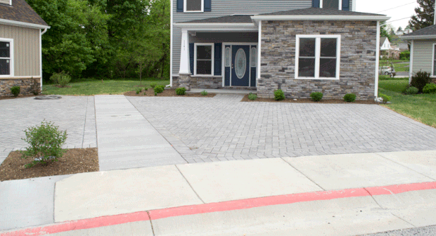
The fine gravel in the spaces between each “porous paver” in this Chicago Park driveway allow water to filter down into a rocky, two-foot deep water storage area. Installing pavers costs about two-and-a-half times more per square foot than pouring concrete.
How stormwater can cause development costs to surge
Say a builder has found land for sale, at an affordable price, and it’s zoned appropriately or they get it rezoned properly for the housing units. That’s hardly the end of the process.
“Stormwater is probably the biggest challenge for urban redevelopment because you just don’t have any extra land,” Snell said. He’s referring to the Virginia Stormwater Management Program from the Department of Environmental Quality, which regulates the quantity and quality of stormwater “discharges,” or runoff, caused by construction activities.
In Harrisonburg, like in most Virginia communities, the program is overseen by that state department, but enforced on the local level.
If a construction project will disturb the ground of at least an acre-sized area, they have to have a city-approved permit for the project that includes best management practices for dealing with that increased stormwater runoff.
The least costly management practices include landscaping measures such as bioretention areas. For example, those areas can be depressions that become natural ponds after a storm or rain gardens. Sometimes they are landscaped areas that collect water to feed vegetation.
However, measures such as these require that part of a lot be set aside for that use.
“In the city, if you’re trying to redevelop, you don’t have a corner of the lot that you can afford to give up. Your corner of your acre is a whole house,” Snell said.
While the same basic regulations apply across the state, developers can have an easier time meeting those regulations in a jurisdiction with lower prices per acre and larger lots for sale, such as Rockingham County.

A small rain garden bioretention area in the Chicago Park development is planted on top of six feet of sand and other natural filters; a pipe buried underneath carries the filtered water under the street to city stormwater pipes.
On small lots in which the builder wants to use the entire surface area, there are pre-manufactured best management practices such as underground cisterns to store excess runoff – but those systems are expensive.
Some city projects may also qualify to purchase “nutrient credits” from a credit bank approved by the Department of Environmental Quality within their watershed to meet water quality regulations. Those credits are generated by stormwater improvement measures which exceed the required regulations for improving water quality on their own plot.
But again, it adds to the pricetag of construction.
While that added costs varies from lot to lot, depending on the stormwater management practices available in each scenario, Snell estimates that, on average, each new house costs an extra $10,000 due to those practices.
But what are the costs of that rising cost of housing? In the next installment in the “Harrisonburg’s housing crunch” series, The Citizen examines who gets priced out of the housing market, and what choices they have. That’s coming next Monday, May 13.
Journalism is changing, and that’s why The Citizen is here. We’re independent. We’re local. We pay our contributors, and the money you give goes directly to the reporting. No overhead. No printing costs. Just facts, stories and context. Thanks for your support.


