

A contributed perspectives piece by Brent Finnegan
Imagine a city in the Shenandoah Valley that is sustainable, prosperous, and affordable. This small, resilient city has the lowest carbon footprint of any city its size in the US. It’s so inherently walkable and bikeable, many residents don’t even need a car for their day-to-day transportation. Families aren’t doubled up in overpriced housing because it’s possible to find decent options in the city that match the size and income level of every local family. And the surrounding county is full of productive farms and healthy forests, not parking lots and low-density suburban sprawl.
I believe that Harrisonburg has the raw ingredients and potential to be that city – a one-of-a-kind American community that took some bold steps and proved to Virginia and to the nation that a better, more sustainable city is possible – even in a Dillon Rule state.
We know the global climate crisis poses an existential threat to humanity. Although the Shenandoah Valley has been spared the worst effects of climate change so far – the Climate Impact Lab map projects that the Valley may be partially buffered from the worst heat waves through the end of the century – there is much more we need to do to reduce carbon emissions locally. And at the same time, we need to address the local affordable housing crisis.
How can we possibly do both at the same time? How do we get from where we are today to an environmentally sustainable, better quality of life for everyone in the city – especially those struggling to find housing they can afford?
We can start by reforming our zoning ordinance. Zoning is one of the few things local governments in Virginia don’t have to ask the General Assembly for permission to change. We have all the authority we need at city hall.
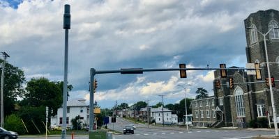
The largest source of greenhouse gas (GHG) emissions in the US is transportation. Although there are national and state programs that may aid in the transition from gas-powered vehicles to EVs, even if all of the vehicles in Harrisonburg switched from gas to electric power, that would not solve the issues of traffic violence, vehicle storage, and heat islands created by massive parking lots. We need to reduce the distances required to travel between work, home, and basic services by encouraging more walkable mixed-use development across the city. We should strive to make cars optional, not required, for getting around town. In other words, we need to densify.
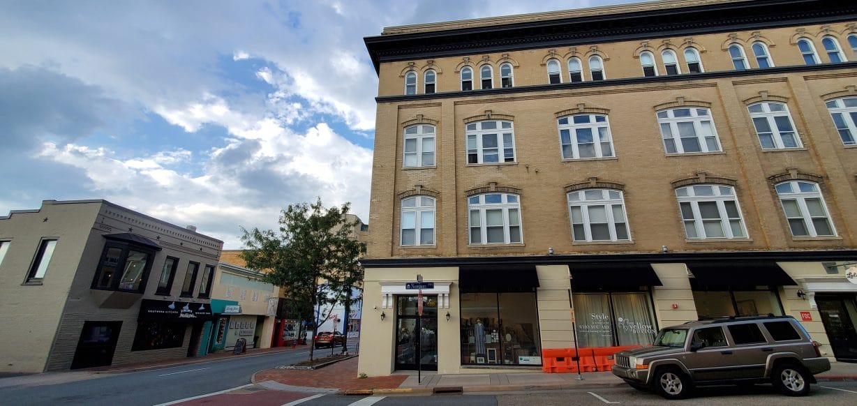
Density may sound scary, but the sort of “Goldilocks zone” medium-density housing needed to meet demand while also slashing household carbon emissions can already be found in Harrisonburg. It’s what the city looked like before car-dependent development became the norm: those iconic mixed-use “three-over-ones” that we all know and love downtown. These structures have been rendered virtually impossible to build elsewhere in the city under our current zoning ordinance.
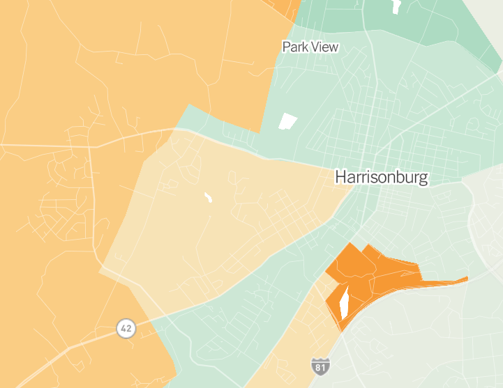
And it’s not just apartment dwellers downtown that have carbon emissions below the national average. The New York Times recently published a map that breaks down carbon footprint per household. UC Berkeley and EcoDataLab took into account the transportation, housing, services, food, and goods consumed by households in each census tract. The Times used that data to produce this map, showing heavier-than-average carbon footprints in orange, and lighter footprints in green.
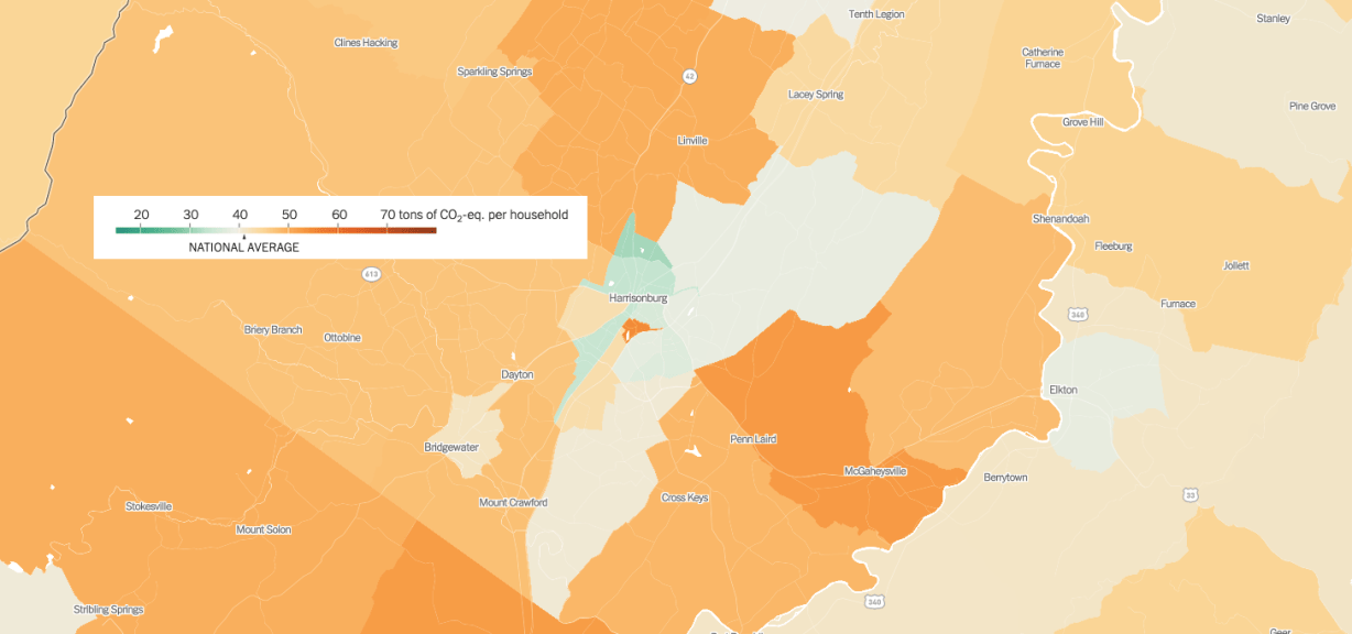
The map reveals that the average household in Rockingham County has a heavier carbon footprint than the average household in the city. This is due in large part to the car-dependent nature of rural and exurban living. The farther you live from schools, jobs, and grocery stores, the more you need to drive.
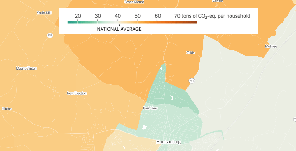
The northernmost section of Harrisonburg stands out as having one of the lowest carbon footprints per household in the Shenandoah Valley. To understand why, we can check our local zoning map for clues. The eastern half is zoned for industrial uses, and has few residential structures as a result.
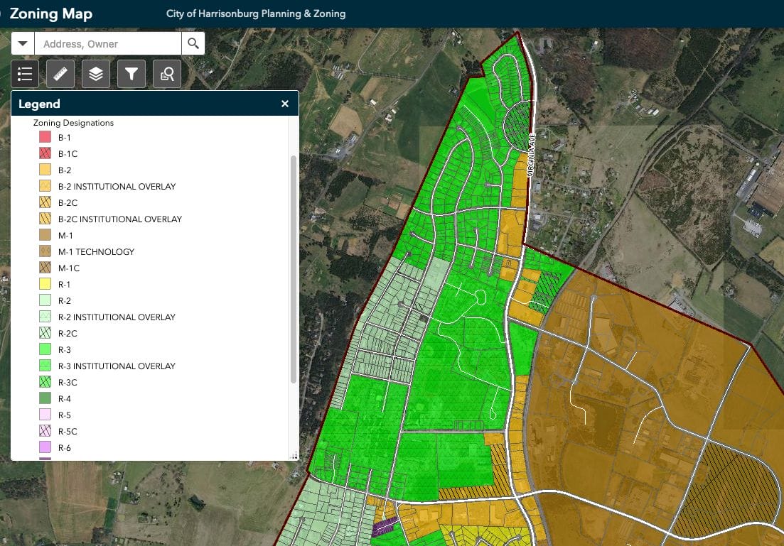
The Harrisonburg zoning map shows that Park View is predominantly:
- Medium-density R-3 (multiplexes, apartments, and townhomes)
- Several R-3 institutional overlays, including EMU and VMRC
- Houses zoned R-2, many of which have nonconforming basement apartments that are illegal elsewhere in the city
Why does this matter? Multifamily housing such as apartments, condos, townhouses, and duplexes makes more efficient use of limited developable land. Compared to single-family detached housing, multifamily housing reduces energy demand and total urban residential energy.
Western Harrisonburg has a higher carbon footprint per-household than most other neighborhoods in the city, save for JMU campus. I asked EcoDataLab why JMU appears to have such a heavy carbon footprint, and EcoDataLab responded:
“The census data we use doesn’t break out campus housing into households very well, and so it looks like [JMU] has very large households (when in fact they’re student dormitories) … We try to correct for this, but our adjustment approach errs on the side of under- rather than over-correcting. We don’t want to mistakenly flag high-emission tracts as low, but that means sometimes low-emission tracts may look unusually high … students are typically very low emissions – low income, low vehicle ownership, small home sizes, and they don’t own their own housing. The neighboring off-campus community can vary, however.”
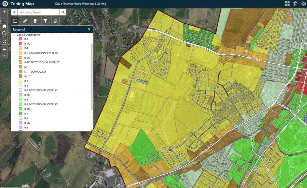
The zoning map reveals that the westernmost section of the city is primarily zoned for R-1 low-density, single-family housing. Allowing more medium-density, mixed-use development can support reaching local, state, and national greenhouse gas reduction targets. The Bluestone Town Center proposal is the sort of medium-density, mixed-use development that can help the city meet demand for affordable housing, while also lowering the overall carbon emissions per-household in the western part of the city (flipping it from orange to green).
The alternative to density in the city is suburban sprawl in Rockingham County. That’s where we’re headed if our current course remains unaltered. The population in the county has been steadily increasing while the population in Harrisonburg has plateaued, due in part to a lack of affordable housing options in the city.
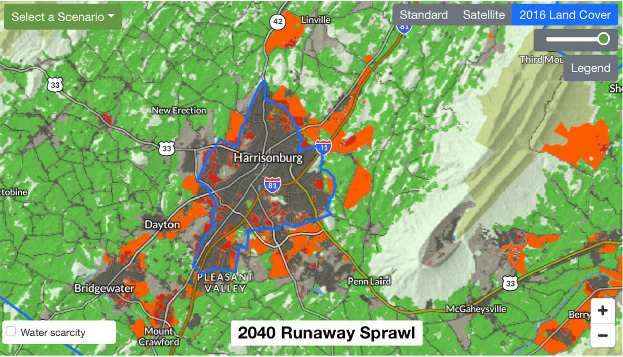
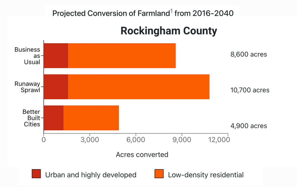
According to the American Farmland Trust report Farms Under Threat 2040, more than 10,000 acres of Rockingham County farmland are projected to be developed by 2040 if the lion’s share of new development gets pushed onto rural land. The good news is that according to this model, we can save more than 5,000 acres of rural land if we encourage compact urban development in Harrisonburg, while also working to minimize sprawl in the county.
The draft chapter of Rockingham County’s updated Comprehensive Plan makes it clear that “new development that would lead to the loss of farms and open space” is a top concern of county residents. It explicitly states, “the county’s greatest assets are its rural and agricultural character,” and “protecting the environment and preventing a strain on natural resources should be a top priority.”
Meanwhile, the Local Workforce Development Area plan projects that regional employment will expand by more than 4,000 jobs in the next few years. So where should the new housing be built?
We’ve spent the last 100 years putting the automobile at the center of local planning and development decisions. We need to put people, not cars, at the center of our planning priorities moving forward. Change doesn’t happen overnight, but positive change in this case will require a shared vision and a community willing to work together with city leaders to make it a reality. Harrisonburg residents will have a chance to give input on this when the zoning and subdivision ordinances update process resumes.
Whether you’re stuck in a backup on I-81 on your daily commute or biking home with groceries from the Friendly City Food Co-op, the reality is that housing policy is climate policy. The sooner we embrace mixed-use, walkable, multifamily housing in Harrisonburg, the brighter our collective future will be.
Brent Finnegan grew up in Rockingham County and has lived in Harrisonburg since 2005, most of that time in multifamily attached housing. He joined the Harrisonburg Planning Commission in 2016 after experiencing a near miss with a pedestrian on Reservoir Street where there is no sidewalk. He currently lives in a house on a small nonconforming lot zoned R-2 that could not be built under the current zoning ordinance.